
Distance: 71.9 miles. Elevation: 8863 ft.
Col d'Evosges | Golet du Thioux | Col de Montgriffon | Col du Nivollet | Col de Montratier | Le Golet | Col du Cendrier | Golet du Tillet | Col de Pisseloup
Like my ride of three days ago, this was another hill-fest, mopping up another nine cols on the western side of the Jura. This one was even longer with significantly more elevation gain.

Anticipating a long day in the saddle, I had prepared a sandwich, my bike (swapped stuff from gravel bike to Colnago), and kit the night before, for a quick getaway this morning.
After a porridge breakfast I left at 9AM and recorded various reports onto my phone throughout the ride.
10:21 from Évosges I got quite an early start. The air was fresh so I wore my rain jacket because the first seven and a half miles were downhill. Because of that easy start I didn’t have my usual pre-ride banana. The road went round the edge of a massive gorge [Gorges de l’Albarine] but there were only slight glimpses of it through the trees and nowhere really to stop. I averaged 20 mph over those first seven and a half miles, putting in no effort whatsoever! Just down and down and down… for 20 minutes. Only a handful of cars passed. The sun is out sometimes but there’s plenty of cloud around.
I’ve stopped here at this village [Évosges] and I’m doing the report from a bus shelter.
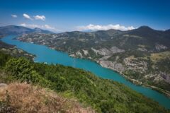
After that first 7½ miles of effortless descent, I had reached river [Albarine] level when my route swerved me to the right, straight up into the forest. It seemed like a very minor road and it felt quite isolated up there. It was very steep – I was in my new first gear (34T rear, 33T front). But I kept slogging away and eventually came to a commune. Just beyond that I saw a view that was too good to miss so I got a photo.

I hadn’t been intending to stop but it was an ideal chance to take my rain jacket off because I was really cooking underneath that with all the effort (and my backpack on).
I assumed I was somewhere near the top anyway, but that turned out to be completely wrong – the road kept going up and up. [In fact that stop came after 2.2 miles of climbing, the previous mile being at 9.5%, with another 2 miles at 6.5% to go] Eventually, for the last couple of miles, it eased up and I was able to change into second and third gears and then eventually into the big ring.
Now I think I have a descent coming up so I’ll put my rain jacket on. I won’t bother eating anything just yet. Standing here at the bus shelter, nearly half the sky is covered in grey thick clouds, so I hope that doesn’t lead to any rain. On that ascent to here only one car passed me on its way up and then the same car coming back down again.
12:05 from Col du Montgriffon From that last stop at Évosges the road descended and I put my rain jacket on, but then the road started climbing again past the lake, but I soon realised it was just up to the Col d’Evosges.

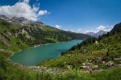
Just beyond the col was a spectacular view over a village [Oncieu]. I walked down a footpath and got some photos.
The road then descended spectacularly down to that village

… and then down to the valley floor and along a main road by the river Albarine. I was glad when my route turned off to the right and immediately started to climb again. I had another bit of my banana. But then shortly after setting off I looked at the Wahoo climbs page and it said it was a 5.8 mile climb taking an hour and 15 minutes so I stopped again to take my rain jacket off and finish the rest of my banana. [That was the second big climb of the day – nearly six miles at over 6% avg, first 3 miles at 7.5%]
The climb was very steep – for ages I was in my new first gear. So I don’t know if the climbs are steep or I’m less fit than I used to be, because I’m using this new first gear a lot, but then again I seem to be going at the same sort of speeds up the hills so maybe I’m just spinning faster, which is probably a good thing.
That last climb gradually flattened out towards the top and I went through a village or two and I’ve just come over Col de Montgriffon.

I’ll have to stop for some decent food shortly. There’s still some blue sky up there but I’d say about 80% cloud now. Although there have been sporadic bursts of sunshine so far, so it’s quite nice really.
14:43 from nowhere special Somewhere up this very slow drag I had to stop. I’m seriously running low on energy and need to eat the other half my sandwich and just have a rest I think.
The road descended from Col de Montgriffon for a few miles to Col du Nivollet, just after which I had half my sandwich. That was a couple of hours ago.

Then came a quite steep four mile descent down to Saint-Rambert-en-Bugey.
Then it was straight into the third big climb of the day; two miles at 8% followed by a mile and a half at 5%. [That led to Le Golet. I didn’t know that at the time but had suspected it because the road reached a high point by some paths in the woods].

After Le Golet there was a 4½ mile descent through the forest to Ambérieu-en-Bugey. Same as during my last ride I found myself essentially ‘off’ the Jura massif and onto the plain to the east of it known as La Bresse. Consequently there were five or six flat miles along a straight main road. Most of it had a separate cycle lane.
At one point they were completely re-laying the road itself, which is something you wouldn’t usually see in the UK. I went through various towns and then came to a roundabout with signs for Hauteville-Lompnes, so I’m on that long nine-mile drag of a climb now and I’ve had to stop to take a break because I’m low on energy. I’ve just had the second half of my sandwich, and a bit of fruit cake. And I’ve moved an energy gel from my back pack to my jersey pocket because I know I’ll be needing it.
Final report Just after that last report my wahoo showed the route going two separate ways. I realised that it was probably one of places where I quickly nip off course to claim a nearby col and then back to the main route. But I should have listened to it when it said go left. I went right thinking the off piste col was that way, and I climbed steeply for quite a while before realising something was wrong. I looked on my phone and saw that I had chosen the wrong way. I briefly considered carrying on without claiming that col, to save me having to climb all the way back again. But no. Dedication to the cause meant I had to turn round and go back, so I descended all the way back to the turn-off and rode up to the col. That mistake turned out to be fortuitous because at the col I met several French cyclists coming up the hill and had a good chat with them.

I asked them whether this was a col. They confirmed it was Col de Montratier. They knew all the cols on my list. I told them I was a member of Club des Cent Cols, which they had heard of.
So after that welcome interlude I had to ride down from there and back up the half a mile I had already climbed once, to continue the slog. The next col on the list came up a few miles later – Col du Cendrier:

About a mile after Col du Cendrier I came to a crossroads where the sign said that Hauteville-Lompnes (where I started the ride) was only 11km, or 7 miles, away. But my route went a different way and I still had nearly 14 miles to go. No doubt that was via another couple of cols.

So I stood there for a few minutes weighing up whether to take the short-cut back. I was so tired it was tempting. But no! Dedication to the cause meant that I had to follow my original route! And so I did.
So I spent another 1 hour 40 mins doing the remaining 1800ft of climbing and claimed 2 more cols, although one of them, Col du Pisseloup, I had already ‘collected’ 18 months ago! Towards the end I was just plodding away slowly, just to get back. The extra low gears on my bike helped.. especially with the very steep climb through the town of Hauteville-Lompnes back to my van.
So that was another good ride done, and 8 more cols collected. The weather had been ideal really, not too hot, but with a coolish northerly wind. I can’t think of any ride I’ve ever done where I took off and put on my rain jacket as much as I did on this one. I guess the profile is a bit lumpy – it certainly had its ups and downs!
Fuel
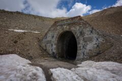
Gallery
Click to enlarge / see slideshow


Nice report ! Thank you Vince !
Merci pour votre commentaire, Thierry.
Vince