
Distance: 66.3 miles. Elevation: 9633 ft.
Col du Marais | Col des Esserieux | Col de l'Epine | Col de l'Arpettaz | Col des Aravis | Col de Merdassier | Col de la Croix Fry
Since my last ride I have relocated 35 miles east, to the town of Thônes, in the Aravis massif. I’d planned this giant col-fest of a route featuring the tough and relatively unknown climb of Col de l’Arpettaz, 9.5 miles long and mostly over 8%. I included six other cols, including the more well-known Col des Aravis. I had originally also included the climb to Col du Plan Bois, for a total ascent of over 12,000 ft for the whole ride. But I decided that was probably too much, so I removed the climb to Col du Plan Bois, thus reducing the distance from 75 miles to 65. It was going to be a long day in the sun, so I left at 09:20, and did frequent reports during the ride.

10:49 I’ve stopped here with 13 miles done [just before Col de l’Epine] and over 3,000 ft of elevation already, according to my Wahoo. In fact I’m not sure that’s true – it seems a bit high [yep, that was the elevation I was at, not the amount climbed – doh!]. I haven’t seen this many cyclists since Mont Ventoux back in October. Loads of clubs were riding out of Thônes. And I’ve passed and been passed by lots of other riders in pairs and solo.
The first col of the day came after just 4 miles of easy climbing, Col du Marais.

The air is quite cool; that’s why I got an early start because it’s supposed to be a sunny warm day. But on the climbs it’s nice and warm with just my arm warmers. I’m just about to go into what looks like a seven mile descent so I will put my rain jacket on for that because in the forests it’s quite cool and the roads are wet from last night’s rain. I’m taking this ride very easy, spinning away as much as I can without pushing anything. So far I’ve turned off for one ‘off-piste’ col [Col des Esserieux]. There didn’t seem to be anything there – it was just the middle of a bit of road from what I could tell. I haven’t had anything to eat yet so I think I’ll just start my banana and then make a move on this descent.
12:11 Well I was right to put my jacket on because that descent down to the valley floor was quite cool. When I reached the main road I noticed there was a bike path on the other side so I crossed and used that. It’s very warm down here in the valley.

It’s a superb cycle path but it veered quite far away from the road and I suddenly wondered if I would be able to get across the road to my turn-off to the col, which was on the other side over to my left. So I stopped to look at my phone, thinking I might have to turn around; I then asked a passing cyclist but he didn’t know because he wasn’t local. He was kind enough to look it up on his phone and pointed out that there was a road coming up that cuts across the main road and onto the climb. Also I asked him if was it a public holiday today because of the plethora of cyclists, and he said yes, so that explains it. [Turns out it was Ascension Day]. I thanked him very much; he was Polish but his English and French were both excellent.
So once I’d cut across the main road I was straight onto the climb to Col de l’Arpettaz, up through farmland and a mixture of pasture with views across the mountains and then sometimes into woods like where I am now.

There were loads of cyclists up until that bike path point, but on this road there’s hardly any at all; in fact just four I’ve seen so far. I don’t really know how far up this climb I am – not very far that’s for sure [answer: 3.3 miles out of 9.5], so I’m gonna have an energy gel and then carry on.
A while ago my Wahoo screwed-up and said that I’d finished the ride (!), so I had to reload the route while still riding along. Then it went a bit screwy again but eventually sorted itself out.
12:57 [3.6 miles from Col de l’Arpettaz] Near the bottom of this climb a cyclist came past me in a downwards direction and said under his breath, but audibly, “worst climb of my f*cking life”. He was clearly not enjoying the work!
Then I passed a couple that were making slow progress up here, and then they passed me when I’d stopped and then further on they’d stopped so I paused for a chat with them, initially in French but then in English. He said there were loads of cyclists earlier because it’s the “long weekend”, and explained that the Col de l’Arpettaz is a little-known climb – only locals know about it – that’s why it’s virtually deserted.

This road is very undulating; there are extremely steep sections of just about 30 or 40 meters and then it almost flattens out for a bit. It’s definitely not a consistent gradient.
I had an energy gel somewhere near the bottom and I’m doing okay at the moment but I don’t know how far it is to go. Out of the forest sections there were amazing views towards the south.
13:39 [About a mile from the top] Ok I’ve stopped here under the only tree I could see for a while. Two riders went past me about a kilometer ago and I was chatting to them; they said there’s about four or five km to go to the top, which didn’t impress me [Luckily they were wrong – it was about half that]. Some of the surface has been quite bad and with gravel, so maybe I now understand what that guy meant when he quipped about the ‘worst climb’ – I think he probably meant the worst descent. But the thing is, this is so quiet it’s unbelievable considering that it’s actually a public holiday in France – I’ve seen one other guy apart from those two who just came past me and then there’s the other two slower ones further down coming up, so there’s only five or six of us on a beautiful sunny public holiday. So far everyone has been able to speak English quite well; I don’t know if that’s because of the area I’m in.
Anyway I was getting hungry with an empty stomach feeling and also a slight headache due to the sun, so I’ve just stopped here and had half my sandwich and painkillers.
15:14 The road surface on the last part of that climb to Col de l’Apettaz was absolutely diabolical, so I now understand what that guy meant when he was swearing about it. There are large patches of gravel, some of it quite deep. A bit of it got stuck between my tire and frame (on the Colnago there is very little clearance between the top of the forks and the 28mm tyres). I had to stop to get it out and I could barely get going again because of sliding on the gravel and the steep gradient. I think I also may have cursed under my breath!
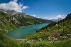
So eventually I reached Col de l’Apettaz, but I didn’t hang about there. There was not much there except beautiful scenery [just the way I like it].

I saw a wooden sign indicating the gravel path that cuts across to Col des Aravis (which would have been an option had I been on my gravel bike, but not today). There was a bit more climbing to do after the col and then the views on the descent were absolutely astounding, Mont Blanc I think.


Some of it was an easy gradient but other bits were quite steep and I really wished I had disc brakes. At the bottom of that descent there was a small climb then another descent down to the main road, which I’m now climbing. My neck is hurting as it often does when there’s lots of descending, but other than that I’m not too bad. I’m just gonna check to see what sort of gradients I’ve got left. There’s 25 miles to go. There was hazy sun earlier but now it’s come out full blast, so I hope I don’t get cooked on the next climb.
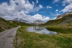
I’ve stopped here overlooking the dam [Barrage des Mottets] on the main road approaching Flumet.
This road, the RD1212, along Gorges de l’Arly, is reportedly the most expensive road in France, repair-cost-wise. It has been almost wiped-out on several occasions due to landslides.
[STOP PRESS: December 2025 – the RD1212 has been closed for the winter after three recent landslides. Not to re-open until the Spring 2026. See here for details]
16:17 So I slowly climbed the main road to Flumet where I topped up both bidons with some water, after asking a couple of cyclists whether it was drinkable. I turned left onto the Col des Aravis road, and I’m about four and a half km from the top, I stopped somewhere to have an energy gel and to get a piece of gravel out of my shoe and have another couple of painkillers. Initially the gradient was okay. The km bournes were saying things like 3%, 2% and in one case even 0%. One of them said 3% yet I was going downhill so I don’t know if it might have said -3%.

Anyway that was all very welcome and the kms were going by quite quickly, but now the road has turned away from the river by the sound of it, so it’s climbing more steeply and I’m seeing 7% mainly, but that’s just average – the road is looking like eight or nine in places. I’m getting very low on energy now, slogging away in first gear. I can’t believe I’ve got no gears left – it’s not that steep in the grand scheme of things.

The sun is really baking now in this hot part of the day, so I’m loving all the bits that are in the shade like this little bit coming up right now. I’ve also taken my snood off even though that gives me some protection for my neck against the sun, but I was just too hot.
So I eventually reached Col des Aravis. And it was absolutely heaving. Cars, motorbikes and people all over the place. There are various shops selling stuff. It was horrible. Almost the exact opposite of Col de l’Arpettaz.

I had been wondering whether there was any more climbing to do. To one of the guys I’d met earlier I’d said that I was doing Col des Aravis followed by Col de la Croix Fry, and he seemed surprised and impressed, so that got me wondering whether I’d got that wrong. But standing at the Col des Aravis I looked on my phone and saw that there was another climb coming up – quite a significant one – well anything was significant at that point! So I sort of assumed it was the Croix Fry. Anyway I put my rain jacket on, finished my sandwich and had another little piece of fruit cake and then set off on the descent. I was glad to get away from all the mayhem at the col.
After three miles of lovely descent I turned left towards the Col de la Croix Fry, heading in the upwards direction once more. It was steep at first but levelled out near the top. It wasn’t too bad in the end, just slogging up there in the blazing sun.
Just before reaching Col de la Croix Fry, my route turned off to the other ‘off piste’ col where I just went up to ‘claim’ the col and back down again. That was Col de Merdassier. It was very peaceful there. Just a farm, and some walkers about. My kind of col.

Then it was back down to Col de la Croix Fry and from then on it was just eight miles of descent all the way home – yay. I really wish I had disk brakes!
A Tale of Two Cols
Col de l’Arpettaz and Col des Aravis, the two principle climbs on today’s ride, are completely different in character.
Col de l’Arpettaz is reached via a narrow road with no markings, twisting steeply up the hillside with magnificent views and, crucially, almost no traffic, by virtue of the fact that it doesn’t really go anywhere other than up from the valley and back down further along, bypassing the town of Ugine. It was peaceful at the top. Some of the road surface was bad, but that was on the ascent for me; it could be tricky in the other direction.
Col des Aravis is a well-known col reached from Flumet via the D909 road which is the main (or ‘only’) road across the Aravis massif. Consequently it’s busier, especially on a public holiday like today. There are quite a few restaurants and shops at the col. Sure, the scenery is superb, but this was tempered somewhat by the noise (especially motorbikes) and mayhem there today.
It’s no doubt obvious which one I preferred!
Fuel
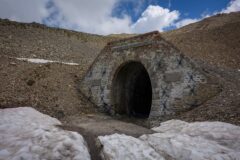
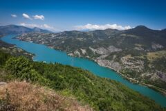
Gallery
Click to enlarge / see slideshow


Thank you Vince for this new biking story. I’ve already passed all the passes, except L’Arpettaz. I hate the col des Aravis, which I came to on the other side : too crowded and too dangerous. Croix Fry and Merdassier are nice end very steep.
Thanks for your comment Thierry. I highly recommend Col de l’Arpettaz, but I advise that you do it from the same side as I did, otherwise the steep descent on loose gravel could be risky.