
Distance: 40.2 miles. Elevation: 2709 ft.
It was inevitable that I would one day revisit the Gorges du Nan. It's a breath-taking piece of road that I first encountered on this ride back in 2016, during my first time in the Vercors. Finding myself staying quite close to it, at Saint-Antoine-l'Abbaye, I decided it would feature in the last ride of this current 5-week cycling tour I'm on.
I had designed a 40-mile loop through Gorges du Nan and back via Presles, but I cut it down to a much shorter ride due to the weather (I wanted to see it in the sunshine) and the fact that I would start my drive back home later in the day, after the ride.
I was idling the day away waiting for the weather to be less overcast, as forecast. It kind of caught me off guard as patches of blue sky began to rapidly replace the grey. I quickly got ready, rushed out the door and onto my bike, covering the 13 miles to Cognin-les-Gorges in haste, aware that the declining sun would be struggling to light the deep NW-SE aligned gorge. I was aware that I had two things against me with respect to the gorge looking as good as it did in May, nine years ago. The first was the lower elevation of the October sun, compounded by the later-in-the-day time of my ride.
So with the feeling I was running out of time I pressed on at a good pace without stopping for much, although I was tempted to take a photo as I crossed the Isère river.

And I couldn't resist getting my camera out once again as I passed the huge 'mouth' of the Gorges du Nan as it exits the massif.

Soon after that I was onto the climb, up through the wooded hillside (on the left in the photo above), the long straight to the first switchback being at 9.3%. It seemed to go on for longer than I'd remembered, probably because I was in a rush. I averaged nearly 6mph which shows I wasn't hanging about.
A handful of cars passed - more than I remember before. Soon I had reached the small tunnel, the entrance to 'Narnia'. I turned my action cam on, hoping to capture the wonderful sense almost of crossing into another world.
Exiting the tunnel I was pleased to see the sun at least still lighting the initial section of road and the rocks above, but most of the rest of the gorge and the road further up was in shadow, as I had feared. I rode a hundred metres or so up the road taking photos and videos and generally taking in the spectacle of it.


I was only up there for fifteen minutes or so before making my way back down. I still had one more thing on my agenda for today, and that was to ride along the D1532 main Grenoble road as far as I could, hoping to reach the landslide that happened just weeks after I was last here on my ride to Montchardon. [More info below.]
So once I was back down in the valley I rode NE along the D1532, not knowing how far I would have to go before I reached the landslide. The good news is that I had the road nearly all to myself. After a mile or so I saw a sign saying there was a diversion, but no road block yet, as the road still led to villages such as Saint-Gervais, which is the start of the climb to the Tunnel Ecouges, a ride I did six years ago.
I rode quite quickly because it was getting late in the day and I only had my rear light, and I didn't know how far it was. Eventually I saw ROUTE BARÉE signs, and just beyond the turn to Saint-Gervais the road was blocked with some barriers that were easy to get round - in fact I cycled round the end of them.

A group of walkers were going to investigate as well. It had taken me fifteen minutes to ride the five miles.
The road was scattered with debris and leaves, having not been maintained for over a year. I came to another blockage where a tree had fallen across the road. It was easy to lift my bike over and carry on riding, right up to the edge of the landslide.

From there, it was impossible to see the extent of the debris. It would have been an ideal opportunity to use my drone, but I hadn't brought it, and anyway I was running quite late. I could have climbed onto the rocks had I had more time - I saw a guy clambering over the rubble from that direction carrying a camera and tripod, exploiting this rare opportunity for some interesting shots, no doubt.
I was only there for a couple of minutes, and after getting some photos I turned around to make my way back. It was slightly uphill for those five miles but I managed a good pace on the largely empty road. Something that kept crossing my mind was concern for the people who had businesses along this section of road, who would have relied on passing traffic for their income. I wonder if the government would compensate them..
So it had been an eventful ride, but it wasn't over yet. Coming into the village of Chatte, I had been doing the right thing and using the cycle path as much as possible when I found myself on a bit that may or may not have been an official cycle path. I went to ride up a very small kerb when my front wheel didn't quite make it and I went crashing into the bushes. That probably would have been reasonably okay, but hiding in the bushes was a sign post which brought me to an abrupt halt, throwing me off my bike, leaving me in a heap on the pavement. A concerned driver asked if I was alright. I said everything was OK.

I picked myself up and was immediately worried that I might have injured myself just hours before having a long drive ahead of me. I had various scratches and bangs but the only thing of concern was a pain in my lower back. The bike looked OK with nothing out of whack so I got back on and rode off. Later I realised I should have checked everything was still on my bike - action cam, rear light, etc - luckily it had all survived the ordeal.
My back was twinging but not painful as I rode the final five miles back to my van, including a couple of climbs. [Everything was OK after a few days].
It was somewhat ironic that I had crashed into a hidden cycling sign while riding on a cycle path. I'll stick to the roads in future - they're safer !
I was glad to have squeezed this sunny ride in on the last day of my 'tour'. But I feel there is unfinished business. I will go back to Gorges du Nan again closer to mid-summer when it will look its best, and I'd like to revisit the landslide to get some drone footage.
The most frustrating thing about today's ride was that I had accidentally set my action cam (with which I have recently had loads of trouble) to manual exposure - just a slip of the finger - so all my clips came out over-exposed and largely unusable. So that's another good reason to go back and get some more footage.
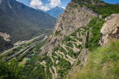
RD 1532 Landslide
Five weeks after my ride to Montchardon in June last year, on the 25th July 2024, a massive landslide of some one million cubic metres of rock covered the RD 1532 road over a length of 470 m and spread towards the Isère river for over 365 m. Miraculously nobody was injured nor reported missing. I have previously driven and cycled along that exact stretch of road.

The internet makes it so easy to do armchair research of the before and after.
Today I rode right up to that point at the bottom of the photo (above) where the road disappears.
Google maps still shows the road as it was, and its aerial view was shot before the landslide.

Whereas IGN maps has a more recent aerial view:

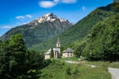
Zooming in on the old aerial shot from Google, I noticed there had been a small chapel next to the road just on the southern edge of the landslide

Unfortunately the chapel was destroyed. It would have been right next to me when I approached the landslide today. The following photo shows the road as it used to be, with the chapel visible through the trees to the right.

... and my photo taken at the exact same spot today:
One can't help but wonder if the landslide had anything to do with the quarry that was situated at that precise location ...
There is now a quite detailed Wikipedia article about the landslide (in French - right-click to translate), including the controversy over possible quarry connection.
The amazing thing about Gorges du Nan is that you don't see it coming. One minute you're riding up an unremarkable wooded hillside. Then a small tunnel appears almost out of nowhere, through which you are transported to a comparative wonderland. I wanted to capture that 'reveal' today, but my camera was set-up wrong and the time of year was also not optimal. So I didn't get any good video today, but here's what the entrance into Gorges du Nan looked like back in 2016:
Gallery
Click to enlarge / see slideshow


Further reading
- Éboulement de La Rivière - Good wikipedia article about the landslide
- Landslide in Isère: D1532 - News article from TF1INFO
- VIDEO - A spectacular landslide in Isère - Another news article with some video
- RD 1532: launch of the study of a new route - Follow-up article


Spectacular ride Vince. Well worth a revisit. Exceptionally well written and researched. Keep it up.
Thanks for your comment Al. More to come…
Cheers, Vince