Distance: 49.2 miles. Elevation: 7842 ft.
Col du Coq | Col de Marcieu | Col du Cucheron | Col du Granier
Pre-ride notes
Today I want to get an early start to this long ride around the eastern ridge of the Chartreuse via Col du Coq and Col du Granier. The weather is supposed to be mainly cloudy with a chance of rain. That could actually be better than blazing sun for today’s tough task.
I was in a real dilemma about the direction of today’s ride (which way round to do it). Each way has its pros and cons, but my original route had a 4-mile 10% climb right near the end, up to col du Granier. So I’ve reversed the route to go clockwise. It means the high point of the ride will come later (Col du Coq) but will be slightly easier towards the end.

I’m going to use my gravel bike as there are some steep climbs. The weather is cooler so I'll wear arm warmers.
12:35
(I don't know what happened to the early start; I didn't set off until 10:40 !)
I have stopped here just outside Saint-Georges, thirteen miles done so far. The weather is mainly cloudy, although the sun is on me at the moment. There is absolutely no traffic around as it's a public holiday today in France. It's cool and most of the mountain tops are covered in clouds. I'm thankful that it's not blazing hot. The temperature is about 22°C. The ride started with that three-mile climb to Col de Granier, which was reasonably OK.


The four-mile descent from Granier, eastwards, was fast and steep; I'm glad I hadn't had to climb it at the end of the ride if I'd done this route the other way round, as originally planned. That descent took me to the lowest point of the ride, altitude-wise, almost off the Chartreuse massif and just a couple of hundred metres above the valley floor.

Then came another five miles and 1500 ft of climbing with quite a few steep bits in there, but it seems to have levelled off now. I'm riding along the eastern flank of the Chartreuse.

There are quite a few cyclists around today but I doubt if I've seen more than 10 cars on the whole journey so far. There is hardly any wind but what there is was actually helping me up that climb to here. I haven't taken too many photos today because I'm eager to press on with this long, tough ride with rain forecast later in the day
13:14
Nothing much to report really. It's been overcast nearly the whole way, which is very good because I have not been in danger of overheating. Every time a climb comes up I take my rain jacket off and when I get to the top I put it on again to keep warm. At that last place I stopped I had half a sandwich. I can't really make out on the map where I am which is frustrating - in other words in relation to any climbs coming up. I've stopped here again to take my rain jacket off because I'm just about to go into another fairly short climb but it is quite warm out today so it's too uncomfortable to have a jacket on when climbing.
Today I have my gravel bike plus the rear mud guard, two bidons and a backpack to keep my rain jacket in, and also my sandwich, and I've got a short sleeved jersey with arm warmers on which I haven't taken off yet.

I spent a lot of this ride looking at the climb page of my Wahoo bike computer. It shows you the gradient profile of the climb, how far left to the top and an estimated time to finish, and how many more climbs left in the ride. I found it quite useful. The only thing missing (maybe it's there somewhere) is the distance to the start of the next climb. (addendum: yes, there is a list of upcoming climbs available on the climbs page of the Wahoo, with the distance to reach the next one)


I was concerned about the Col de Coq climb, but it was OK in the end as it wasn't that long from this side, 3.5 miles.

There were three or four elevation bournes; they all said over 9%. And that's average - I saw 12% and more on my Wahoo.


After getting the obligatory col photo, I started the descent from the Col du Coq only to be confronted with a 'route barrée' sign.

My heart sank. Then I saw a cyclist coming up, which gave me hope. I asked him if the road was open and he said yes. That was a relief.
I'd read about the bad road surface on this west side of Col du Coq and now I was here to experience it first-hand. It descends very steeply through the forest and the road is quite uneven. It was a real bone-shaker. Not very pleasant at all. I'm glad I had the 35mm tyres of my gravel bike.
(Later I discovered that this road was closed between December 2017 and the summer of 2019 after a landslide during Storm Eleanor displaced 3,000 m³ of mud and rocks, causing the stream to divert and wash away some of the road - either that, or the landslide fell directly over the road - reports vary - more info below)

There was over seven miles of descent (including a brief climb) down to La Diat, at which point I found myself in familiar territory when my route joined the road coming down from Col de Porte, which I'd been on five days prior.
The road surface had improved approaching Saint-Pierre-de-Chartreuse, where the Église de Saint-Hugues-de-Chartreuse had a striking art installation propped-up against it.

I saw some thick dark clouds over the mountains and thought the rain was coming. There had been fine rain in the air at the Col de Coq but it hadn't lasted.
From La Diat I headed north on the 2½ mile 8% climb to Col du Cucheron, the first half mile of which was at 12%. This section was the reverse of my ride from last Thursday.

There followed a very welcome five miles of downhill to Saint-Pierre-d'Entremont.

All that remained for me was an easier three-mile climb back to my campsite at Entremont-le-Vieux. The rain hadn't materialised and the sun even made a few brief appearances for a nice end to another amazing ride in the Chartreuse.

Today I think I managed the whole thing well. I took it easy on the climbs, got my breathing right, had an energy gel about a mile before the four big climbs of the day and ate my sandwich piecemeal instead of all at once. Also today I had the easier gears of the gravel bike and the lack of sun blasting on me. And all that made it easier than Col de Porte even though there was more frequent, and steeper, climbing. Today I seemed to be able to just keep going.
Video of Chartreuse and Route
I created a video to show where the Chartreuse massif is situated in the Alps and also the routes of my past four rides here. It looks better in full screen (press Esc to exit).
Further reading
- La Lettre de Saint-Pierre-de-Chartreuse July/August 2019 edition of the local newsletter, with an article covering the repair of the Col du Coq road (in French - right-click to translate).
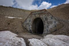
- Réseau de la Dent de Crolles Not really cycling-related, but there are over 60 km of interconnected natural underground passages lying beneath le Dent de Crolles, with eighteen entrances into this network of caves.
My goodness, while researching this area I discovered that Mont Granier has suffered several landslides in the past couple of decades, of some concern to the residents of Entremont-le-Vieux, where I was staying for this ride. Also there have been landslides at the Néron, and Dent de Crolles. Indeed they appear to be happening on a continual basis all over the Alps. Just goes to show that nothing lasts forever, even mountains!
More info here.
Fuel
Gallery
Click to enlarge / see slideshow