Distance: 52.8 miles. Elevation: 6327 ft.
This was another ‘up-the-valley-and-back’ kind of ride. From Briançon it’s twenty miles to Pré de Madame Carle, a wonderful open area at the head of the Vallouise valley. The road ends a couple of miles short of Barre des Écrins, the highest peak in the Massif des Écrins and the Dauphiné Alps, on the other side of which lies La Bérarde, destination of another beautiful ride from Bourg d’Oisans.

I planned a route to Pré de Madame Carle and added a 4-mile steep climb along La vallée de l’Onde to the west and then back via the ski station above Puy Saint Vincent. It didn’t all go to plan but was nevertheless a spectacular day’s riding.
I left at 09:20 after a porridge and honey breakfast. Reports at various points in the ride:
10:32 (after 13.8 miles) The weather is wall-to-wall blue skies but it was a freezing cold start, 0°C, at 9 o’clock. I’m in my full winter gear including roubaix long sleeve top and merino wool base layer. The first bit of the ride was downhill along the main road, following the same course as my ride on the Boucle d’Izoard earlier this year. My hands and feet were frozen (my Wahoo measured as low as -2°C). After 4 miles, at Prelles, I turned off the main road onto that quiet back road (Route des Traverses, D4) where there was some climbing to be done, and during that section my hands warmed up but my feet didn’t. I was happy when the sun was on me. There was quite a bit of descent on that bit which I realised will be further climbing on the way back home.
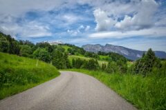
After nine miles, at Les Vigneaux, the route turned off from my previous one. I was riding on unknown roads, gently climbing through small villages as I headed into the heart of the Parc National des Écrins.


Two or three electric mountain bikers had gone by. Then a guy rode up next to me and we chatted for a while. He was French and was also going to Pré de Madame Carle.
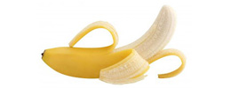
Just after the village of Le Claux I stopped to take off my rain jacket. But I didn’t have my backpack on me so I had to squeeze it into the pocket where my banana was so I ate half my banana and stuffed it in my empty bidon which I’ve already got an energy gel and some cakes in.

The road doubles back on itself through a tunnel and crosses the river. The gradient increased after that.

Earlier a group of five or six club cyclists had gone by. Standing here doing the report they’ve just descended past me so they must have gone up and turned around. I’ve just eaten the second half of my banana and I can tell how chilly the air is because the banana was really cold!
So the road climbs up the valley with massive mountains to the left and right and you can sort of sense where the valley ends ahead. There’s a rushing stream always in earshot. Sometimes a bridge crosses it.

I’ve been coming up through the woods, sometimes in sun but actually preferably in shade now. I can already feel that my back is sweating even though I haven’t got my rain jacket on.

I was finding it reasonable, thinking ‘well this is okay’ and then suddenly I’ve hit a section which I sort of knew was on the profile, probably about eight or nine percent [edit: in fact nearer to 10%].
Earlier I had looked at the Wahoo and calculated that the end of the this climb was about three and a half miles further, at the 20-mile mark. From where I am now I’m guessing there’s about another two to go, hopefully.
11:09 Report from Pré de Madame Carle
Just after setting off after the last report, that guy I’d been speaking to earlier came down past me and shouted “you’re nearly there”. I shouted “good!”. That section was really tough. Twice I checked to see if I didn’t have a lower gear. I realised that he may just have said that to keep my morale up. But after a short while the gradient eased.

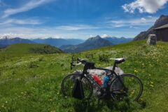
Here at the end of the road I’m at 1800m and it’s taken me 20 miles to get here, whereas yesterday I had reached 2000m in 6 miles!
I’m standing in the sun. There is a large car park here and about 20 or 30 cars and vans. I can hear running water near me, just a waterfall. But over the other side I can hear more of a rush. I can see a glacier (Glacier Blanc) that I assume is feeding the river. I’m just going to have half my sandwich.


Final report
After my sandwich and mini cake I went over to see what the rushing water sound was. A path went into the sparse woods. A sign said no mountain biking; I thought “well I’m not on a MTB”, so I rode slowly along the path. You could go further but I didn’t fancy it. I saw a waterfall which was the source of the noise.

So I started back down the valley. The road surface was excellent so you can ride at a good speed. I stopped somewhere to put my rain jacket on.

I saw more and more cyclists and cars coming up – it’s certainly a popular spot. And understandably so. It’s a very beautiful valley.

After 30 minutes of downhill back to Vallouise my route crossed the river and started heading up the second climb of the day.

It started off easy. Then just as the steep bit was due to start I came to a ROUTE BARRÉ sign in front of a road block.

I had a quick look past the sign – the road had collapsed due to flooding. Reading the posted notice I saw that the road was closed to ALL vehicles and pedestrians.

Damn! I had been robbed of another 1200 ft of climbing over 3.2 miles. I turned around back to Vallouise and went straight into the next climb. This was a newer, wider road to the Station 1600 ski station above Puy St Vincent. It was at a rock solid 7% for 4.4 miles. There were occasional views but mostly trees got in the way. I eventually saw the buildings of the ski station way up high and thought ‘surely I’m not going all the way up there!’ Inevitably, I was. I was plagued by flies on that climb. I did it in one go without stopping.
[Note: On two separate occasions I saw brown furry squirelly type things running across the road ahead of me – not sure what they were]

Because of the fly situation I didn’t stop there for my sandwich but went straight into the fast descent, after putting my rain jacket on. Instead of descending all the way back to Vallouise, I turned right after 2.5 miles to take the road through Puy-Saint-Vincent back down to Les Vigneaux, where I stopped to have the rest of my sandwich and took my rain jacket off again in preparation for the next three miles of fairly gentle ascent.

The quiet road, La Route des Traverses (D4), now quite familiar to me, has wonderful views over the Durance valley.


At Prelles I re-joined the main road for the remaining five miles back to base.
It had been another amazing ride from Briançon, with perfect weather, albeit a tad chilly. The ride to Pré de Madame Carle was beautiful; a largely unspoilt valley road, (unlike some others I could mention – yes, Val Ferret, I’m looking at you!), with spectacular mountain scenery. The second climb, to the ski station, was uninspiring, as I expected, and I only did it for the sake of it. Of course everything is relative – if that road was available in SE England I would be on it every day! It’s a shame the road along La vallée de l’Onde was blocked off for repair – I expect that would also have been unspoilt. Maybe I’ll do that another day…
Further reading
- Pré de Madame Carle Information from the tourist board
- Siphon de l’Argentière Fascinating (to me!) information about the arched penstock, which apprently is not really a siphon!
- The Legend of Madame Carle’s Meadow What lies behind the name
- Barre des Écrins Wikipedia article about this famous peak.
Fuel
Gallery
Click to enlarge / see slideshow