Distance: 38.3 miles. Elevation: 7815 ft.
Staying here in the Maurienne valley, I have many rides planned, the first of which is Col de la Madeleine. There are two ways up there from the La Chambre; the usual D213 ‘official’ route, and another one to the west of the valley (du Bugeon) which is quieter, but steeper and with poorer road surface. I always prefer a loop if I can do one, so I decided to go up the quiet one, which joins the other one for the last couple of miles to the top, and down the normal one because it’s easier to ascend on poor surface and descend on good.
I was aware (from savoie-route.fr) that there is currently a roadblock listed halfway up the climb, but the wording was vague, and I hoped I might get past it OK.
It was forecast to be a hot day with quite a bit of sunshine, so I wore light kit with no base layer, my ultra-ventilated helmet and my neck protector, and plenty of sun block. Backpack had food, energy gels and rainjacket. I left at 09:50 after a porridge and honey breakfast and a PRB. I stopped for various reports during the ride.
10:43 Well it’s a hot (and humid unfortunately) day. I’ve stopped here at 3.8 miles. There have been about five cars so far, so about one every 10 minutes. Luckily I’ve been either in the shade or the sun’s gone in or it’s just a bit of a hazy sun and still quite low in the sky. Nevertheless it’s enough to make me know that I don’t want to be under that for a long period. I stopped near the bottom to get a photo of a church. It was 10:00 exactly, and chimed! A good sign that things are normal.

I haven’t stopped since and I’ve been looking out for somewhere to stop after the nine-miles-to-go-to-the-top point, but as usual the Wahoo has screwed up and thinks I’ve finished the climb even though I’m halfway up it.
Slogging away slowly at one point near the bottom I thought I’d better resort to my lowest gear, only to find out I was already in it! So that was a disappointment. And I’ve been in it ever since. It’s a fairly lumpy gradient – lots of double figures percent but in general 8 something comes up on the Wahoo. The view down to La Chambre is magnificent, making me realise how far I’ve already climbed. And there must be an airport near here because I’ve been above low flying aircraft; one a jet and one a turbo-prop. It’s odd to look down on aircraft from above. So there are plenty of clouds in the sky and that for me is a very good thing. One of the main reasons I’ve stopped is that I’m getting a pain in the side of my head which I’ve had before where the buckle of the neck protector thing digs into my temple. So I’m going to adjust that before moving on.
It’s extremely peaceful. All I can hear are the insects and the birds whistling and a slight hum of activity down in the valley, but very faint. There are plenty of butterflies and I can hear lizards scuttling about, although I haven’t seen any yet, at the side of the road
11:23 [This report done while riding along, using action cam audio, later voice-recognised using my phone! First time I’ve done this. A useful way of getting stuff down as it happens but then I have to find it on the video and convert to text]
Just after Montgellafrey there was a wall of really steep straight road and after that it’s been reasonably okay for quite a while. I saw the sign that says ‘road blocked ahead’. Luckily there was a mountain biker there and I asked his advice. He said there are rocks on the road and you may get by. He seemed fairly confident.
I’ve just been passed by another road cyclist so he’s gonna have to get through [the road block] so I don’t want to see him coming back down here.
12:59 I’ve stopped at Montoudras [about 3½ miles up the second climb]. First time I’ve stopped on the second climb today, now on the ‘normal’ route to Col de la Madeleine. Just a few minutes after that last report, I reached the fenced-off road, unfortunately just as that other cyclist was coming back through it.

He said it was too dangerous, with rocks on the road and that he was going to go by the forest route (I didn’t know there was one). I went past the fence to have a look for myself.
So yeah the roadblock on that other road was dangerous and there were rocks falling even as I stood there, and I looked up higher to see workers, so whatever they were doing was dislodging the rocks.

I swore under my breath and decided to descend down again and try to do the other side.
So I turned around. As I rode back I looked up at the forest and it looked insanely high and rocky ahead of me so I didn’t fancy that.

When I reached the road closed sign the guy was still there with the mountain bike so I chatted with him. I asked if he’d just seen the road cyclist and he said he’s gone up there, pointing up a side road going up into the forest. He said that he knew the forest route and it’s very difficult even on a mountain bike and certainly not advisable on a road bike. So that made my mind up to not even think about that.
So I descended back the way I had come. On the way down I passed a single cyclist and two groups of four or five coming up and each one of them I warned that there were rocks falling off the mountain and it was much too dangerous to ride, but in the same way that I would have done they carried on riding anyway to see for themselves.
Passing the same church as before, it was now 12:00 and chimed as I went by! I stopped briefly at my van, thinking I now didn’t have enough food, etc [wrong]. I had a croissant thing and a glass of water, grabbed another energy gel and some fruit cake and got back on my bike and started the ascent of the other road, and that’s where I’ve stopped around about here.

So thankfully, and I don’t normally say this, the sky is 100% overcast at the moment and that is absolutely ideal because it’s a hot day and the temperature is just right at the moment. This road I’m on, the main one to Col de la Madeleine, is extremely quiet considering it’s the main road. Obviously the time is now one o’clock so lunchtime for most French people – maybe it will get busier in a minute but I’m just plodding up here. There have been sections of 8% I’ve seen on the signs, maybe a 9. But it’s nowhere near as steep as the other side, that’s for sure, and the road surface is pretty good. So it’s quite peaceful at the moment, just the birds singing, and I’m just gonna carry on after this break.
13:56 I’ve stopped at a place where there’s a bus shelter so I’m sitting in there.

This will probably be my last proper stop. It’s five miles to go – should be less than an hour and a half [In fact just 1hr and 8mins with 2 mins stoppage]. Luckily the sun still hasn’t come out so it’s been perfect temperature, still very warm and sweaty obviously. The kilometre signs seem to be all over the place – one said 9% and yet the following kilometre was quite easy so it was definitely wrong. At times there have been extremely steep sections like through that avalanche gallery where it was easily 11% for ages but in general it’s about 8% and manageable by just grinding away up there. If it stays at 8% I’ll be happy with that.
Final report So I carried on slogging away, nearly all in first gear. I’m sure every borne kilométrique said 8%. I think I stopped briefly 2 more times. It’s amazing how refreshed you feel after just a minute of rest. I started drinking more on the last couple of miles. The route went through an ugly ski station town …

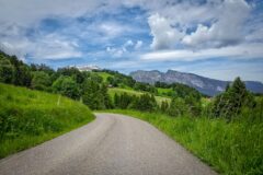
… and once I’d cleared that it was just nice mountain scenery.

A few riders went past me on the last stretch. I was expecting to see the point at which the other route joined this one but didn’t notice anything. And still there was hardly any traffic at all.
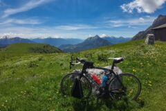
I reached the top and got a col photo. My bike blew over in the wind for one photo, but didn’t suffer.

A group of young french cyclists asked me to take their photo; I did, then they reciprocated.

I chatted to them a bit. They said I had ‘old school’ brakes! I said I prefer discs for descents. I told them that Col de la Madeleine is not really 2,000 m. I told them, slowly in french, it was 1,996 m, but I think it’s actually only 1,993 m.
I mentioned the Club de Cent Cols. They told me about “Le Sept Majeurs”, a challenge I’d never heard of, in which you must climb 7 of the highest passes in the southern french and italian alps. They listed some, but their list was wrong (I discovered later). They said Colle delle Finestre was included but it isn’t. Nor is Galibier or Iseran, because they’re not in the south. But they have given me another list to try to complete – I have 4 of the 7 already.
I rode over to look at the view north and at the panorama information boards. It’s quite cloudy today and not that clear, but I could make out most of the peaks named on the boards. Mont Blanc was cloud covered, as is common. I bet the view from Col de la Madeleine on a clear day would be amazing.

I put my rain jacket on over the top of my backpack to stop it sliding around on my back, which it is prone to do on descents. I did the whole 12-mile descent without stopping, in 27 minutes. The road in general was good but with some rough patches here and there. I prefer the wider, softer tyres (and of course the disc brakes) of my gravel bike for descending. The air warmed up as I approached La Chambre, but it wasn’t stifling even though it was quite still and humid.
So that’s another well-known col ticked off my list. I still would have preferred to have done it all via the quieter but steeper western route. I’ve just looked and I see that the western climb joins the other one to the north of the ski town abomination, Saint François Longchamp, so I would have avoided going through that. I’ve just looked at the map and seen that I had been 2½ miles from meeting the other road after the road block, and the gradient would have eased considerably! Still, going back down and up the other side added to the challenge, and I’m glad I decided to not give up. The weather helped. I remember saying to the guy near the road block that I would consider going down and back up the other side if the weather wasn’t so warm. But in the end the weather was just about perfect, mainly overcast or hazy, but plenty of sunshine at the end for some nice photos!
Notes
- On that first western-most ascent there was no mention whatsoever on any signpost of Col de la Madeleine
- Also there was no sign at the bottom saying that the road was closed ahead!
- I didn’t need all that extra food. You only need loads like that on long epic rides, not simply going up to a pass and back. So that was extra weight I’d carried for no reason…
- Col de la Madeleine is only 1,993m. They have exaggerated wildly to give it more kudos. From my point of view Col de Sarenne gets more respect with its honest 1,999m !
- At the col and the roadblock I inadvertently left my action cam recordiing, probably because of being distracted by someone talking to me. That’s the second time in the past few rides where I have done that. But it enabled me to include conversation in the video.
Further reading
- Col de la Madeleine French wikipedia article (has more info than English one)
- Les 7 Majeurs Detailed info about the challenge
Fuel
Gallery
Click to enlarge / see slideshow