Distance: 51 miles. Elevation: 8437 ft.
Cormet d'Arêches | Col du Pré | Col de Méraillet | Cormet de Roselend
Almost a year ago to the day I did a ride featuring three lakes. During that ride, whilst gazing over the waters of Lac de Saint-Guérin, I saw a track on the far side climbing to higher ground and I wondered if it went anywhere useful. Looking at maps after that ride, I discovered that there is a gravel route over the mountains, via Cormet d’Arêches, back down to the Isère valley. So I designed a circular route from Bourg-Saint-Maurice, over Cormet d’Arêches and down towards Beaufort but veering off over the steep side of Col du Pré to Lac de Roselend and then over Cormet de Roselend back down to B-S-M.
Report from Cormet d’Arêches I left at just after 9am. The temperature was very cold. I have my arm warmers, rain jacket, snood over my head, cap and helmet. And long-fingered gloves. Just through Bourg-Saint-Maurice there is a turn-off that climbs up the side of the valley and the road runs along the side of the main valley but keeps climbing further up. Through different villages.


Eventually the road turns inland and still seems to go around the edge of a valley but now it’s wooded, with not many houses around. There was a very steep straightish climb through forest until you get to the bit where the road officially runs out, I think. But it’s still surfaced at that point. The only people I saw were forest workers. Then the road starts climbing up some switchbacks extremely steeply. The road was damp and covered in wet cow pats.
Eventually the forest gave way and there was a clear mountain view ahead, up the valley, still with lots of cows around, their bells ringing. That section is very steep and I was wondering where the gravel part might come. I could see a small white building very high up ahead of me, either a chapel or a refuge.

I was hoping I wouldn’t be going that far up, but it was almost inevitable that I would be. The road starts going up the right hand side of the valley in a series of switchbacks and the good news is that these are quite a reasonable gradient, maybe 7 or 8%, so still in first gear but at least manageable.


Just after I reached that refuge the road turned to gravel.

But it’s really just rocks with some gravel and loads of compacted mud, some of which was quite wet because of the rain we’ve had lately, and my tyres don’t have much tread on them. The really good news is that the gravel section isn’t that steep – I’ll have to look when I get back – I’m guessing six or seven percent. (That guess was completely wrong – in fact the 4.8 mile climb to the col is avg 9.2%, and it never drops below 8. The steep section in the forest earlier was over 11%).

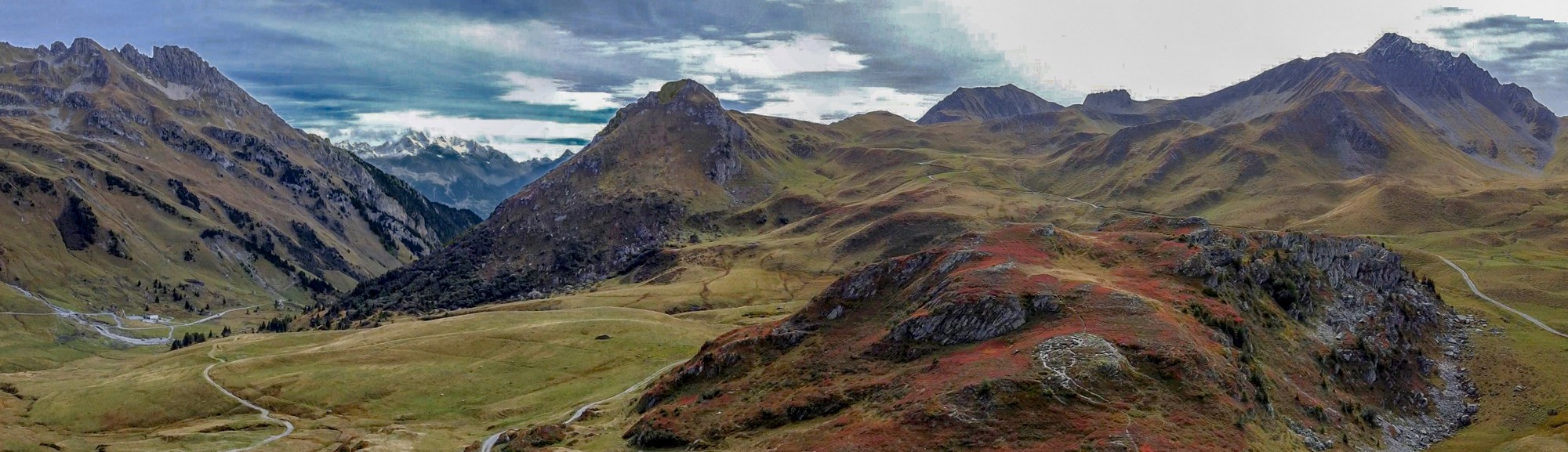
It’s a really beautiful section at the top here. I’ve got the marmots’ shrills echoing across the rocks, but there are more buildings and cars than I would like, and people walking. It’s probably really busy in the summer, which would ruin the whole atmosphere I think. The sun has been mainly out, sometimes through hazy high cloud but now I’m standing here at the top the clouds are definitely building up ahead so I’ve put my rain jacket on and am eating half my sandwich and I’ll see what the descent down to the lake is like. One rider came past me but he had an electric bike.
I thought I was getting an altitude headache so I took some painkillers. The mobile signal at the top here is absolutely brilliant.
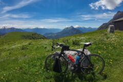
Decided to give my drone a quick fly

Report from end of ride I rode down to where the col sign is and got a photo.

There were a few cars there. The surface quality of the descent was no better; in fact in places it was worse. I expect more drivers come up this way than the other.
The scenery was spectacular. The descent felt steeper than the other side. (Wrong again – it starts off at 9%, about the same as the ascent, and averages 8.7% for more than 3 miles down to near the lake before it climbs again.)
I took it really slowly, dodging between rocks and dips in the road. I tried to avoid the mud. My hands were on the brakes the whole time and I couldn’t really look at the scenery because you can’t take your eyes off the ground in front. Which is why it’s best to stop now and again to take it all in.
Lac de Saint-Guérin comes into view quite soon after leaving Cormet d’Arêches; about 7 minutes judging by photo timestamps.

The road passes another lake and there are improving views of the main one.

Suddenly, still quite far from reaching the lake, I noticed I was back on poor, but welcome, tarmac.
There is a path right down by the lake but my route stayed on the road further up the hillside and even climbed briefly before dropping down to the car park area by the dam.


I got some photos but didn’t hang about and went straight into the descent. Now the climb to Col du Pré was coming up, so that was on my mind.
I was wondering how far I would descend before joining the Col du Pré climb, and it turned out to be quite far. I recognised the bridge where you have to stay in a straight line on the metal strips to prevent your wheels getting stuck in the metal grid. Carrying my momentum into the Col du Pré turn-off I stayed in 2nd gear for quite a while, and mused “well this isn’t as bad as I thought”. I stopped after a couple of switchbacks to take my rain jacket off and remove the snood from round my head. That’s when I used my only energy gel.

When I got the chance, I looked over and saw the now small Saint-Guérin dam wall high up in the distance behind me and was ruing the elevation (potential energy) I’d lost in the descent from there. That Col du Pré climb is tough. There are some small variations in gradient, but it averages 9.4% for 3.5 miles and took me just under an hour. Inevitably I had dropped to first gear quite soon and stopped one more time for a painkiller. My back was aching and I’d never completely got rid of that altitude headache from earlier. The sun had gone in completely by now, which was probably a good thing. The air was cold but I was keeping warm through the effort.
I got a col picture and carried on climbing (Col du Pré is not quite at the top).


Then the view of Lac de Roselend opens out before you. I stopped to get photos and put my rain jacket and snood back on. While I stood there two jet fighters soared through the mountains and over the lake.

I descended to the lake and straight over the dam and around to the chapel without stopping.

I went in the chapel and got photos of all the info inside, which I hadn’t done the previous time I was there. There are some old photos of what the valley looked like before it was flooded by the lake – it looked beautiful. This chapel is a rebuilt version of the original one submerged by the lake (more info below).

I sat outside and had my sandwich, overlooking the lake. With no energy gels and only a couple of sips of energy juice left in my bidon, I was hoping I’d be ok on the final climb of the day to Cormet de Roselend. I didn’t remember it being particularly steep last time. There were km signs so I knew it was 5 miles to the col (cormet) from a point before the chapel. From the chapel it’s just over 4 miles and averages 6.7% for the start of the climb. I slogged my way up there in 47 minutes stopping for a couple of shots of the lake, and of marmots.


I left my rain jacket on for the ascent and wasn’t particularly hot. Fortunately it’s one of those climbs where the gradient eases at the top and the last km was only at 4%. I’d made it. No more climbing to do today! I got a col photo and then straight into the descent back down to Bourg-Saint-Maurice.

That’s when the fun began. It’s a brilliant descent because the relatively easy gradient means you can let go of the brakes, except for the lacets. Despite the air temperature being cold I wasn’t freezing on the downhill.
I was just thinking about what a fast descent this is when I came around a bend and saw the road blocked by herd of sheep. My rapid progress was halted while I waited for a way through.

Obeying the expert whistling of the shepherd(ess), the sheepdogs quickly moved all the sheep over to the side of the road and I could get through. See the video for all the fun.

It was an exhilarating descent back to Bourg-Saint-Maurice with spectacular scenery, including a deep gorge towards the bottom. I was buzzing by the time I got back to my van. Too much fun to stop for photos.
There was no traffic around. Not a single car passed me during those 25 fun-packed minutes to the outskirts of B-S-M.
My feet were warm the whole ride but my hands were cold when I got back.
I really enjoyed this ride. I had conquered another gravel col, with amazing views of Lac de Saint-Guérin; I had climbed the tough side of Col du Pré; I had photographed all the historic details in the chapel, and I even flew my drone! Another great day riding.
In contrast to my past few rides in Aosta Valley, today the roads were not lined with armco and those overly neat (but attractive in a touristy way I suppose) stone walls and loads of road markings and signs. This was my sort of wild col. Great to be back in France!
Further reading
Rocher du Vent – The mountain at the NE end of Lac de Roselend (wikipedia)
EDF, la construction du barrage de Roselend Early video of the construction of the dam.
Travaux Barrage de Roselend Video of work on the dam when the lake was drained. Unfortunately no shots of the submerged village.
The word “Cormet” comes from the Franco-Provençal dialect (also known as Arpitan), which was historically spoken in the Alps region spanning parts of France, Switzerland, and Italy. It likely derives from the Latin word ‘culmen’ (meaning summit or peak), which evolved regionally into ‘cormet’ to mean a high pass between two valleys.
Info about Chapelle de Roselend This chapel replaces the old chapel dating from before the 14th century, originally located in the heart of the hamlet of Roselend, at the end of the present-day lake. The semi-domed chevet and the Romanesque-style bell tower bear witness to this period. Its medieval origins are attested by a 15th-century seigneurial document.
Mass was celebrated there every Sunday from the beginning of June until the third Sunday in October. The services of July 22nd (Saint Mary Magdalene) and May 15th were particularly well attended. In the registered cemetery, the rector buried the deceased from October to June; in other months, burials took place in Beaufort.
To prevent their chapel from being looted during the French Revolution, the inhabitants of the hamlet decided to hide the two cast iron bells by burying them in the soft surrounding soil. With peace restored, they hastened to unearth the bells, but found only one, which was immediately replaced. The chapel was dismantled stone by stone before being rebuilt in its current location, thanks to the determination of the inhabitants of Roselend. It now watches over the submerged village…
Inside, the statuette of Our Lady of Monte Berico was presented on 9 May 1959 by the parish priest of San Quirico, in Veneto, as a sign of moral support to his compatriots working on the construction site.


Fuel
Gallery
Click to enlarge / see slideshow


Hello Vince,
What a magnificent loop and what a beautiful report!
You brought back wonderful memories of the Cormet d’Arêches, and above all, you were braver than me with the Col du Pré – Cormet de Roselend combination!
Thank you Joris for your comment. I’m glad it brought back some memories for you. Cheers, Vince
Thanks for yet another outstanding report Vince, the pictures are brilliant as usual and the video is the icing on the cake, well done! I had no idea that there was a submerged village under the lake, and enjoyed the historic photos of the old village and church. What are you thoughts on riding this loop in the opposite (counter-clockwise) direction from Beaufort?
Thanks
Martin
Thanks for your comment Martin. Much appreciated.
Re. counter-clockwise from Beaufort, I’d say it was much of a muchness (as my dad says). You’d start with a 12 mile (20k) climb past Lac de St-Guérin to Cormet d’Arêches, averaging 7% but with the last 2 miles (3.3k) at 8.5% on gravel. (There is more gravel that side than the other). Then the descent to B-st-M, followed by the 12 mile (20k) climb to Cormet de Roselend at 7%, down to the lake and back via D925, where you could quickly divert 2km (no real climbing) to visit Lac de la Gittaz, and descend to Beaufort. Or you could come back via the Col du Pré descent.
Cheers
Vince
Hi Vince, just to let you know, my browser threw an Https error which could just be my machine. But beyond that, a lovely report as ever.
My question, how fluent are you in French?
I’ve been over a bit this summer and can read/say things, but conversationally I’m useless.
Hi Ben,
Thanks for the info. My ISP is upgrading systems atm – hopefully it was due to that. I’ll check.
Thanks for your comment.
Re: french. I can usually have a conversation of sorts with most people I meet. There are exceptions!
Cheers
Vince
You have excelled yourself with this my dear friend .. I plunder my directories of French bon mots and superlatives and sayings but none of them will do it the justice 😉
Thanks Jame, your comment is much appreciated.
Cheers
Vince