Distance: 42.3 miles. Elevation: 5331 ft.
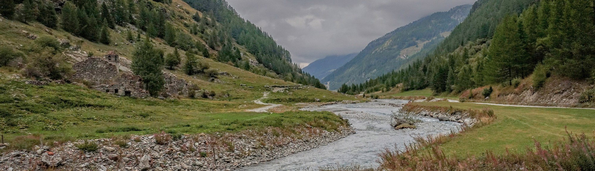
Another ride along another valley off the Aosta Valley. Maybe I’ll try to collect the whole set in time! This one is Valgrisenche valley, carved by its river, Dora di Valgrisenche, a right tributary of the Dora Baltea (the river in Aosta Valley). I designed a route a few years ago to start from near the foot of the valley, but while I’m staying at Morgex, I decided to ride to it from here, adding a further 20 miles. The route loops around Lake Beauregard and the small chapel at the head of the lake, Cappella di Chatelet, returning via what I hoped would be a ‘navigable’ gravel track. I was unable to confirm 100% whether this was doable from maps alone. See below for the significance of the chapel, which I only discovered later.
I left it late starting the ride because the weather forecast said it might be sunny out later and more likely to be dryer later. So I set off at 12:30.
I wore three quarter shorts, long-sleeve base layer with a short-sleeve top, Woolie Boolie socks, a snood and a cap under my helmet, and in my backpack I had arm warmers and long-fingered gloves plus an additional spare inner tube because of the gravel section I was going to be doing.
The weather was cold (13°C) and dull. Grey clouds hung low over the mountains ahead. The first couple of miles were on a bike path by the river, which avoided going on the main road at least as far as La Salle. I felt spots of rain a couple of times and didn’t really hold out much hope that I would complete this ride.

The next 6 miles were on the main road, but gently descending so there was no real effort required. There’s a space at the edge of the road where you can ride without encroaching on the main traffic lane. The only problem was three tunnels in which you don’t get the extra bit of road to ride on. I was lucky in the tunnels as I didn’t have any cars come up behind me.
I felt some more raindrops, and with the grey-looking skies ahead, my mood wasn’t that good but I thought I’d just go as far as I could until it started raining. At Leverogne I turned off the main road and immediately started climbing a crazy set of hairpins up to Rochefort. I took my rain jacket off and put it in my backpack before the climbing started.

The road didn’t really stop climbing, always at a steep gradient. The first 5 miles we’re at 9%. There were several tunnels. Two had lights and one had like natural windows to let the light in. One of the tunnels was the steepest tunnel I’ve ever been in – I was in first gear and breathing hard so it must have been mid to higher teens% all the way through it. It had recently been resurfaced and when I got out the other side I noticed that there was an old road that it had bypassed, so it could be quite a new tunnel I think. Looking back of course I wish I’d investigated the old road, but on the way up this climb I wasn’t really stopping for anything, just seeing how far I could get. I stopped for a couple of photos, both waterfalls.
The road was damp and the sky was grey and the clouds were still lingering over the mountains ahead of me but at least it wasn’t raining.
I noticed that some of the road surface on the other side the road was in really poor shape so I was gonna have to watch out for that on the descent.
Because it had rained earlier and the sky was looking so threatening and it was fairly late in the day, I didn’t want to risk the gravel section on the other side of the lake, so I had in mind that I was just gonna go up to as far as I could, then turn around and come back, without looping round the lake.
The road was all through forest with a massive gorge to the left, but you couldn’t really see anything. There was always the sound of rushing water. The air was cool but I was keeping warm just through the effort. Looks like it was between 8 and 10°C according to the Wahoo.

Eventually the road started going through some pasture with cows grazing. And the gradient eased up. I thought that by going up this valley I would end up in the middle of nowhere but there had been tiny hamlets that I’d pass through and then suddenly there was a reasonably large place called Valgridenche, which is also the name of the river that’s formed this valley. There were lots of things in place for visitors like car parks, etc and even a bus went by me and someone got off at one of the bus stops in one of the villages so it wasn’t really the middle of nowhere.

At one point I saw the dam – yay, but in fact it went out of view and I didn’t see it for ages after that and the road started climbing steeply up the side of the valley again. I kept looking to my left to see if I could see the dam or the lake. Eventually I did see the lake and I was much higher above it than I’d expected.

Also I could see the gravel path right next to the lake far below and it looked quite reasonable to ride on from that distance, so I was encouraged to consider going all the way around the lake as planned.
The road kept climbing for another two miles leaving the lake far below.


Eventually I saw from my wahoo that I’d reached the top of the ride.

So this was the time to make a decision – but in fact I’d already sort of half decided to carry on all the way around the lake. But there was bound to be a massive descent ahead of me before that and if anything went wrong I really wouldn’t want to climb back up that again.
So I put my rain jacket on and descended towards the end of the lake where I could see there were some buildings. There was a beautiful view looking further up the valley going higher and it looked like there was a sort of a gravel road going up there, which could be very interesting to do, heading towards the French border, with Val d’Isère the other side.

Eventually I saw the chapel which is the name of this post.

So the road plunged down via a series of switchbacks and across a bridge and then headed back along the other side of the lake. Initially this was all tarmac past a couple of buildings and a restaurant.

Then I saw the gravel road to my left. It said no entry but I know that cyclists have used this so I just carried on down it.

Initially it was quite steep. It descends down to river level and then along eventually to be beside the lake. The surface was excellent; sometimes there were some large stones but in general it was more like a dusty track – very smooth.


I was quite anxious on this section in case I got a puncture because now I was away from civilization, and with the weather, and the day getting late, these things play on your mind. But in fact even on that section, nearer to the dam, I came across a man walking his dog.

Somewhere near the dam there was a couple of short but extremely steep sections of the gravel path and you have to really do your best to keep your speed going because you can’t go slow on steep gravel else your back wheel would just slip. So by the time I reached the look-out for the dam I was panting profusely after just coming up an extremely steep ramp. Just before the dam was an area with picnic tables; I went down there to get some photos. So I can’t be the only one who’s interested in looking at dams!


Riding away from the dam I was back on tarmac. And after another steep ramp the road descended and led back to Valgrisenche, where I rejoined my original route. I stopped just outside there to quickly have half my sandwich, but mainly to put my arm warmers on and my long-fingered gloves. Then I started the descent.

The descent was very fast because of the steep gradient and I was glad once again to have disc brakes and wide tires when I came across that uneven surface I was talking about earlier. But in general it wasn’t too much of a problem.


Although the air was cold I didn’t feel too bad with my triple layers and long-fingered gloves.
Eventually I was back down at the main road and from then on it was a slight uphill for the next seven or eight miles. I stayed on the main road to Morgex without using the cycle path by the river. Again I was fairly lucky getting through the tunnels without traffic behind me. The rest of the road had that space at the edge where you could keep out the way. By this time the sky was clearing; it was still cloudy but not so oppressive. Not that it mattered now because I had completed the task.
I’m glad I had persevered. It had stayed dry, and to some extent the heavy-looking weather led to some evocative views. By the time I got back, my mood, like the weather, had lifted. The restorative power of cycling – and the inspiring power of mountains, lakes and rivers.
Further reading
- The Cappella di Chatelet is a reminder of the events surrounding the construction of the Beauregard dam. The small chapel was erected in 1959, when the churches of Fornet, Beauregard and Usellières had been covered by the lake. For this reason it houses many of the furnishings from the submerged buildings, such as the altar inherited from Fornet or the statue of Saint Ursus by Giovanni Comoletti, originally in the chapel of Beauregard. The bells also ring out their previous history, the large one coming from Fornet and the three small ones from Surier, Chappuy and Beauregard.
- Lake Beauregard Very interesting article describes how the dam wall and the lake level used to be much higher but was reduced due to “problems of stability of the ground along the banks of the lake”
- La nuova diga di Beauregard Excellent video documenting the reduction of the dam.
- Beauregard Dam More info about the dam.
- Dam photos Excellent collection of photos including dynamiting of the dam wall to reduce its height.
- The Beauregard Dam and the submerged villages More info including map of the submerged villages.
- Valgrisenche (valley) List of peaks, passes and refuges relating to the valley
- Dora Baltea The river of Aosta Valley
Gallery
Click to enlarge / see slideshow


Thanks again for taking the time to share your adventures with us Vince . After a long, long Canadian winter these are a great spring tonic. Thanks also for digging up the additional reading on these locations which is much appreciated. The youtube link to the dam modification led me to some of the work of Ermanno Olmi who documented (youtube) some of the dam construction of that post war period, hard work indeed!
Cheers
Martin
Thanks for your comment Martin.
On the subject of dams there is related information about the terrible tragedy at The Vajont Dam (Wikipedia).
I hope my next post will interest you because it answers a question you asked a while ago about Cormet d’Arêches (coming soon, hopefully)
Cheers
Vince